EUR
EUR CAD
CAD AUD
AUD GBP
GBP MXN
MXN HKD
HKD CNY
CNY MYR
MYR SEK
SEK SGD
SGD CHF
CHF THB
THB SAR
SAR AED
AEDA Legendary Map Collection to Benefit MapAction is Enroute at Guernsey's
"What can we do to help the world with maps?"
This was the question moving through the mind of Farhad Vladi, a discerning collector of maps and the foremost international island broker (a delightfully kismet combination of interests). Over the course of his near five-decade career, Vladi has sold more than 2,000 private islands and amassed an extraordinary selection of antique maps - a passion which started out as a generous gesture. Whenever Farhad Vladi represented an island, he would seek out antique maps of said islands to give as a gift to his clients, and it was this thoughtful quest that would burgeon into a world-class collection of his own. As a member of the International Map Collectors Society, Vladi has traveled the world in his quest to amass a collection of the finest, rarest, and most beautiful maps he could find. The collection he assembled is a true depiction of the history of European map making, encompassing four hundred years of cartographic development with a focus on maps predating the 19th-century. So, what exactly can these maps do to help the world? A lot, actually.
MapAction Past & Future Package included in Guernsey's auction helps to fund MapAction’s ability to support future emergencies.
In collaboration with MapAction, a humanitarian organization which works across the globe to ensure disaster response teams have access to the maps and data they need - Guernsey's will auction 'The Legendary Vladi Collection of Historical Maps' on September 23 and offer nearly 300 examples of the finest quality historical and antique maps, as well as three specialized MapAction packages. A portion of the auction proceeds will be donated to the organization in addition to the full proceeds following the sale of the MapAction Past & Future Packages which allows the winning bidder to select a map from a back-catalogue of thousands of maps. Once selected, the map will be a framed, printed version, signed by one or more of the team members who attended the emergency and made that chosen map.
.jpeg)
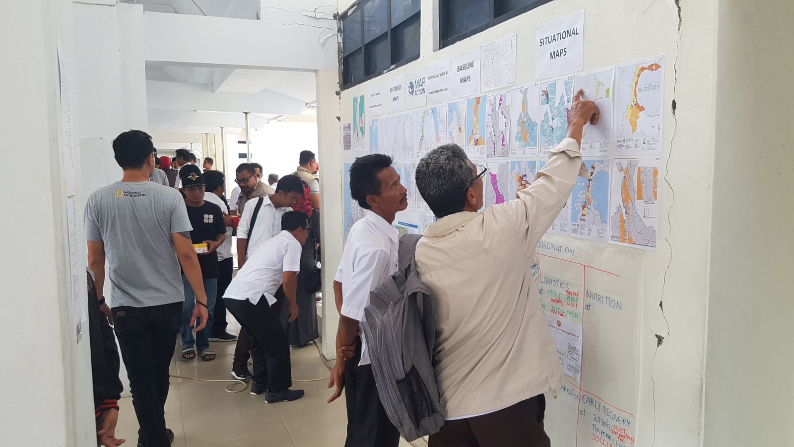
MapAction; Map detailing the site of the Beirut Explosion in Lebanon, August 2020
MapAction will also provide a short description of the purpose and situation for which the map was made. The best part is that in buying a map from a past emergency you will also be helping to fund MapAction’s ability to support future emergencies. It costs on average $40,000 to send a fully trained, equipped and supported response team to a humanitarian emergency at short notice. For nearly two decades, MapAction’s emergency mapping services have aided responders with every crisis imaginable, from earthquakes to armed conflicts to COVID-19 and the recent Beirut explosion. Through geographical information and data, MapAction supports first responders in providing the best information to coordinate their efforts, allowing aid to be delivered effectively and efficiently to save as many lives as possible.
Now, with hundreds of years between them, the world’s most noted cartographers including Gerard Mercator, Willem Jansz Blaeu, Abraham Ortelius, Johann Baptist Homann, Sebastian Münster, and Matthäus Seutter, will help to further that incentive.
Here are some of the superb highlights featured in the upcoming sale with detailed descriptions from the Specialists at Guernsey's:
1) Ortelius, Abraham, Theatrum Orbis Terrarum (atlas), 1574
.jpeg)
Ortelius' monumental work 'theatrum Orbis terrarum' is commonly regarded as the first modern atlas. The 'Theatrum' is generally considered a milestone in the history of cartography. The title page is of an allegorical nature. Seated at the top we see a female figure representing Europe, superior to all other figures. She wears the imperial crown, and carries a scepter in her right hand and a rudder in the form of a cross in her left hand. Asia is portrayed to the left, holding a container of incense in her left hand and wearing a gown beset with precious stones. To the right we see Africa, scantily clad and holding a palm branch in her hand. In foreground, on the left, America can also be found, forming perhaps the most interesting figure of this title page. She depicted to be naked and holds a cudgel in her right hand and a male human head in her left hand. Her weapons consist of a bow and arrows. Columbus and Amerigo Vespucci reported on how bows and arrows were used as weapons in America, as did Hans Staden, a German from Hamburg, who was held captive in Brazil for nine months. In 1554, he returned to Europe and he published a book about his adventures, which were later translated into Dutch and French and printed by Plantin.
2) Mercator, Gerard, Tabulae Geographica (atlas) 1585 & 1589

Outstanding first edition of a work by Gerard Mercator, published when the author was still alive. The first three segments were first made available in 1585 under the name "Tabulae Geographicae", consisting of "Galiae" (France), "Belgii Inferioris" (The Benelux countries), and Germaniicae" (Germany). The fourth part, "Italiae, Sclavoniae et Graeciae" (Italy, Balkan and Greece) was published four years later. The fifth and last part, "Atlantis Pars Altera" (not part of this edition) was published in 1595, one year after the death of Mercator. The edition offered here contains two more map, presumably authored by Mercator's son, Rumhold. The first is a world map (first Atlas edition), the second a map of Europe. The latter was most likely not intended for publication in an Atlas, as there is no text on verso. One particularity is the map of Lombardy (Lombardiae III. Tab.), as the text on verso is printed inverted to the frontal view. The elaborate leather binding dates back to the 17th Century.
3) Wit, Frederick de, General Atlas, 1656-1666

An interesting Dutch composite atlas which includes an early dated issue of de Wit's twin-hemispherical world map (the first of three types); several maps of Asia, Africa and the Americas (all 1660), and a map of Denmark (1659). A selection of rare maps by Hugo Allard - who is known to have collaborated closely with de Wit - are also included; as is a fine example of Allard's 'Novii Belgii' (1656), his 'dioecesis leodiensis' (not listed in Koeman), and an unsigned and undated version of 'nova et accurata... hispaniae,' which features four borders and is not recorded by Koeman. Franz Carelsz' 'comitatus Hollandiae' is also included, but not recorded.
4) Schedel, Hartmann, Das Buch der Chroniken (atlas) 1493

Hartmann Schedel's 'Liber chronicarum' is considered to be the most extensive illustrated printed book of the 15th century. Detailing six different ages, the Chronicle combines descriptions of famous cities with representations of historical events and references to the biblical story of salvation. The narrative follows the pattern of the universal Latin and vernacular chronicles of the Middle Ages. Parallel to the biblical story other places, events and individual town descriptions are also featured, including, for example, the founding of the city of Trier at the time of the Patriarch Abraham (3rd World Age, XXIII recto).
Hartmann Schedel put a special emphasis on describing the most important cities of Germany and the occident. The collection - made up of 1804 illustrations and 652 woodblocks - serves as a fascinating document of the nascent art of printing. The map includes the first documented appearance of many cities and includes a lot of detailed information, including their founding stories, the etymology of their name and a meticulous collection of contemporary facts of culture, economy and trade. Schedel drew from a variety of different sources, including other handwritten chronicles, leaflets, medical literature, the contemporary works of the Italian and German Renaissance, other geographical and cosmographic literature and the works of Ptolemy and Strabo.
The woodcut work carried out by Michael Wohlgemuths (1434/37-1519) and his stepson Wilhelm Pleydenwurff, within his Nuremberg workshop - an establishment renowned for its spectacular woodcuts, altars and sculptures and which soon emerged as a specialist in the new art of book illustration. Further mentions include references to the printer - Anton Koberger - and the German Renaissance artist, Albrecht Durer. Durer is known to have learned in the workshop between 30th November, 1486 and 1st December, 1489. The possibility of Durer's involvement in the Nuremberg Chronicle has been discussed in detail by Erwin Panofsky (1943). The dynamic brushwork and the skillful technique of some of the engravings - a marked contrast to some of the other woodcuts of the chronicle - suggest that the young Durer may have assisted with at least the preparatory drawings of some woodcuts. The idea is yet to be confirmed.
5) Seutter, Matthaus, General Atlas, C. 1735

This 50 double-page engraved map-sheets includes a distance table and a plate containing various flags of the world. The collection also includes 15 maps by Homann and his heirs and a wonderful, contemporary body colour map by Gabriel Bodenehr. Some maps include index tabs and four of the maps are taken from another copy (World, celestial chart, Europe and Canada). There is no title page. At first glance, it's easy to come to the conclusion that the atlas perhaps formed part of the previous volume. It is a remnant of a large collection of maps, such as a copy of his Grosser atlas which also contained maps by the Homann family (Wardington Catalogue).
_____________________________________
Join us in supporting MapAction by registering to bid live in Guernsey's 'The Legendary Vladi Collection of Historical Maps ' auction, September 23, 12pm EDT.
Don't have a Bidsquare account? Sign up here!
Be in the know about upcoming auctions and exciting post-sale results by following us on Facebook and Instagram.
Similar Posts
-
 A Celebration of Sports History and Collectibles
 -
 The Thrill of Sports Memorabilia Auctions: A Collector’s Paradise
 -
 Snoopy & Friends: A “Peanuts” Auction at Revere
 -
 Beached in Brighton
 -
 Unveiling the Elegance: Antique Canes Auction
 -
 Nostalgic Treasures: Exploring the Legacy of Hubley Toys
 -
 The Evolution and Enduring Legacy of Barbie: A Timeless Icon
 -
 Own a Piece of California State History
- Wild at Heart: Wildlife Masterpieces to Watch at This Year's Premier Western Art Auction
- Timeless Timepieces and Exceptional Finds Lead This July Luxury Auction
- Five Standout Lots to Watch in This Palm Beach Estate Auction
- From Viking Warriors to Napoleon: Five Historic Arms and Armor Highlights to Watch
- Five Standout Breweriana Treasures to Watch at the NABA Rare Beer Cans & Breweriana Auction
- Four Landscape Masterpieces That Capture the Spirit of the American West
- Objects of Affection: Discover Rare Jay Strongwater Editions and Luxury Decorative Arts
- Celebrating 250 Years of American History Through Extraordinary Artifacts
- From Contemporary Design Icons to Historic Treasures: Five Standout Lots from a Dallas Designer's Collection
- Four Standout Jewels to Watch in This Exceptional Estate Jewelry Auction